

Automated Processing and Analysis of Data
The TLS data files are very large which requires greater processing power and storage than can be handled at most agency locations.
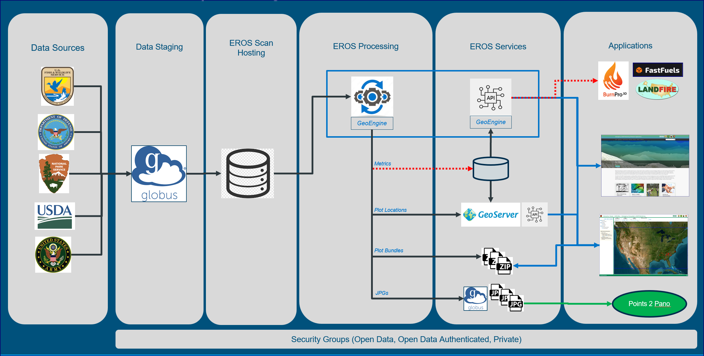
TLS data collected through our monitoring protocols are processed automatically using the IntELiMon processing pipeline maintained by USGS Earth Resources Observation and Science (EROS). EROS has the capability to store these thousands of scans, and process the data files, as well as display the resulting metrics. Each TLS scan taken in the field can be directly uploaded through IntELiMon on the EROS server, where they are processed and archived with explicit metadata for each dataset. This initial processing results in 100’s of structural ‘metrics’ calculated from each TLS dataset (3D ‘point cloud’), and when coupled with initial transect field data, are used in a machine learning environment to predict tree and fuels data used in forestry and ecological monitoring. EROS is capable of processing 100 TLS datasets per day and the results are delivered via the IntELiMon Viewer.
Aerial LiDAR
The increasing availability of high-resolution airborne laser scanning (ALS) datasets, referred to as aerial LiDAR, is revolutionizing data collection and analysis across research and resource management fields, including cultural resource management. In the last decade, ALS-derived digital terrain models (DTMs) have emerged as a leading tool in identifying and documenting above-surface archaeological sites and features throughout the United States. Advances in ground surface visualizations and new uses of machine-learning are paving the way for next-generation tools to support heritage programs. Direct benefits of ALS applications include increasing the efficiency and effectiveness of current cultural resource survey methods, advancing methods for archaeological site investigation and detection, allowing for rapid post-disturbance triage of sensitive sites and resources, and assisting managers in mitigating impacts of changing climate (i.e., wildfire, hurricanes, etc.) on heritage landscapes and cultural resources. The New Mexico Consortium’s Cultural Resource Sciences program is currently advancing ALS applications in cultural resource management through coordinated processing of ALS datasets collected by the US Fish and Wildlife Service and expanding machine-learning applications to map and monitor above-ground archaeological resources on public lands.

Example of ALS visualizations revealing above-ground archaeological sites. Left: Aerial imagery of the historical townsite of Fullerton, Louisiana. Right: ALS-derived visualization of Fullerton, Louisiana showing building foundations, roadways, and other historic infrastructure.
EROS
The TLS data files are very large, so greater processing power and storage is necessary. USGS Earth Resources Observation and Science (EROS) has the capabilities to store these thousands of scans, and process the data files, as well as display the resulting metrics. The EROS team also developed a great interactive viewer data dashboard, InTELimon – Interagency Ecosystem LiDAR Monitoring, for easy data access and download.
IntELiMon Viewer
The IntELiMon Viewer serves as a dashboard for users to access the processed TLS data, metadata, and the results of the processing and analyses. Quality control/quality assurance and metadata management is built into the data workflow.
Viewer: https://dmsdata.cr.usgs.gov/lidar-monitoring/viewer
Accessing EROS Data Processing services (Onboarding SOP)
To acquire TLS monitoring data processing services through USGS EROS (IntELiMon), the site and plot locations need to be in the system. An onboarding standard operating protocol (link above) has been developed with USGS as the definitive means to accessing EROS data processing service. Onboarding your site must be completed before any scans can be uploaded.